Kurt and I awake in Naples, Florida. The drive the
night before had been uneventful and now we are only miles from Big Cypress
National Preserve, which borders on the Everglades National Park. We stop
at a fruit stand just east of Naples to grab a breakfast of fresh fruit (yummy!)
before heading into Big Cypress. We stop at the visitors center off US Highway
41 to read briefly about the panthers in the area (after all we are going
to be camping out later, this is good information!). Once very prolific, this
elegant cat species has now been reduced to 12 known individuals within the
Big Cypress Preserve. Sadly enough, the panthers primary predator is the
car. After looking around the Center for a bit, we walk a short distance down
a near-by path. Its at this point that we finally see our first alligators
in the wild lounging in a small pond in back of the building. There are
also several other very lengthy foot trails and scenic drives leading across
the prairie that we could venture down if we werent so anxious to investigate
the real Everglades.
We continue on through Big Cypress and soon find ourselves
in the Everglades National Park an area extremely devoted to preservation.
In sharp contrast to the National Preserve, the National Park does not allow
off-road vehicles (not even airboats) anywhere within its boundaries. We also
notice from the map that there are relatively few hiking trails in the Everglades.
(Although there are plenty where we will be spending the night.) We stop at
the Shark Valley Visitor Center just a few miles after entering the Park,
where we decide to hop on a tram tour that will last about 2 hours and take
us 7 miles into the wilderness.
Im not quite sure what to say about the Everglades.
I guess the main point I want to express is how much I learn about the ecosystem
during our short 24-hour visit. First, Kurt and I of course have the wrong
impression of what the Everglades should look like. We both have this Hollywood
image of swampland, towering Cypress trees, and Spanish Moss hanging everywhere.
We couldnt have been more wrong. The Everglades is a River of Grass or
a Wetland Prairie. Grassland stretches from horizon to horizon, broken only
by the occasional hard wood hammock. Our tram guide informs us that, figuratively
speaking, southern Florida is bordered on the west by the Naples Mountains
and on the east by the Miami Mountains even though the actual elevation
change from these coasts to the Everglades is a mere 30 feet or so. She explains
that in the Everglades, an elevation change of just a few inches has a huge
impact on the vegetation. During the wet season, Lake Okeechobee to the north
fills with water that eventually spills over and flows down the entire southern
tip of the Florida peninsula into the Gulf of Mexico. The water moves at a
rate of 100 feet per day, providing a lush habitat for water foul, fish, alligators
and a myriad of other creatures (yes, like mosquitoes!).
The Park is bordered on the east by the city of Miami.
The western portion of the park consists of marshland, numerous tiny keys,
and waterways. (This is the actual area where the slow-moving water flows
into the Gulf.) We had read before leaving on this trip that there is a 10-12
day canoe trip available leading from Everglades City to the Flamingo Visitor
Center. This waterway (the Wilderness Waterway) snakes through the islands,
bays and rivers just inland of the Gulf. Because there is very little dry
ground to sleep on, the Park Service has built elevated, thatched-roof huts
called chickees. This will have to be another trip for Kurt and I.
The southern portion of the Everglades is actually
Florida Bay, the section of water between mainland Florida and the Keys. Much
of the water in this bay is only 4 or 6 feet deep. If you knew the way, I
think you could literally walk from the southern tip of the mainland to Key
West.
Our tram tour, while uneventful, is certainly enlightening.
I more than get my fill of alligators in the wild. Every water hole alongside
the road has an alligator in it. We even spy tons of baby alligators, distinctive
by their yellow stripes which they dont lose until they are around 4 years
old. At the southern point of our tram ride, our guide stops the train to
let us climb a 3-story observation tower and gain a better view of our surroundings.
Once back in the Toyota, we continue on towards our
destination; Flamingo Campground on the very southern coast of the Florida
mainland. To get there, we have to exit Everglades National Park and venture
through the suburbs of Miami. We stop for a bite to eat at a very authentic-looking
Mexican restaurant. I have flashbacks of our trip to the Grand Canyon last
year as our waitress speaks only broken English and Kurt decides to go ethnic
and order a sesos taco. Now I didnt know what sesos was before entering this
restaurant, but I will never forget again! Its cows brain
and it definitely
looks like cows brain, texture and all. It is not in the least bit disguised.
Kurt eats it all, without making too many faces. All he can say about it is
that it tastes very sweet. I dont think hell order it again any time soon.
On our way back into the Everglades, we pass a very
large fruit stand called Robert is Here. We have actually read about this
fruit stand a guy named the stand for his young son many years ago, at which
point in time the business was not doing well. But for some reason the intriguing
name brought new business and now Robert himself can usually be found in the
store showing off his prize fruits nearly every day. We think he is the individual
who actually invites us out to observe his turtle and bird sanctuary in back
of the store. We purchase a bag-full of fresh key limes and head back toward
the Everglades.
Once at our campground, which is about 30 miles into
the Park, we can no longer feel the effects of civilization just a short distance
away. We find our designated camping area and pick a spot to pitch the tent
only 20 or so yards from the edge of the Florida Bay. Racing against the twilight,
we set up the tent, then head out to find a good hiking trail. We embark on
one called the Coastal Prairie Trail that looks as though it should lead right
along the edge of the water. After about a half mile, we do manage to see
the water through a thick grove of trees. Kurt and I pick our way through
these trees and attempt to get as close to the water as possible. We can get
as close as about 5 feet to the water before we discover that the roots of
the trees (which are partly above ground and very gnarled-looking) are way
too thick for us to go any farther. We continue on down the path, with the
trees still separating us from the water. We finally round a bend and are
rewarded with a decent view of the bay. It is obvious by this time that sandy
beaches just dont exist in the Everglades: the waters edge consists of thick
mud and a nasty smell. After snapping a few pictures, Kurt and I begin down
the path once again. By this time, I just cannot get away from the mosquitoes!
They follow me everywhere by the dozen and I even slathered myself with repellent
prior to starting the hike. Eventually they start bugging Kurt too, and he
votes to head back to the Toyota. Its getting dark and the trail doesnt
promise much of a water view anytime soon.
Our next course of action is to explore the rest of
the Flamingo area. We find the Visitors Center, the cabins for rent, the
restaurant, the marina and the general store. We take a few minutes to wander
around the marina and the general store where we purchase additional mosquito
repellent and a bit of beer and then head to the restaurant for dinner.
The host tells us that we need a reservation and that his next open one is
about an hour and a half away. We put our names in and head outside to kill
a bit of time.
The building is on the edge of the water, and at the
base of the stairs we find a monument and plaque dedicated to an Audubon warden
who was killed by feather hunters in the early part of the 20th
century. We decide that it will make the perfect virtual geocache! (Again,
see www.geocaching.com for details.)
We write down the details and take several GPS readings to determine the location
as closely as possible this way we can log it on the website for others
to find.
At last its time to head to the restaurant for our
reservation. Our tables not quite ready when we get there, so we sit at the
bar and chat with the bartender until it is. After dinner Kurt and I head
back to the tent, grab a few beers and sit at the edge of the water to relax
for a bit. We see a faint glow of city lights across the bay and determine
it must be the lights of Key West. Ah
what fun it would be to go back there
instead of going home tomorrow... (To
Day 10)
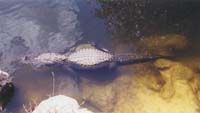 Shark Valley Everglades Alligator
 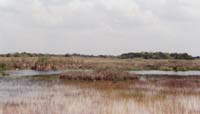 Everglades
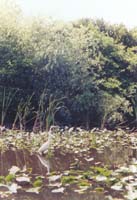
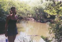 Alligator and Carmen
 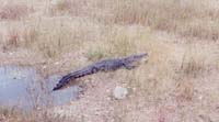 Shark Valley Everglades Alligator
 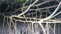 Everglades
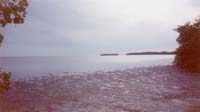 Gulf of Mexico